|
CUYAHOGA RIVER
|
 |
 |
 |
 |
 |
 |
 |
 |
 |
 |
 |
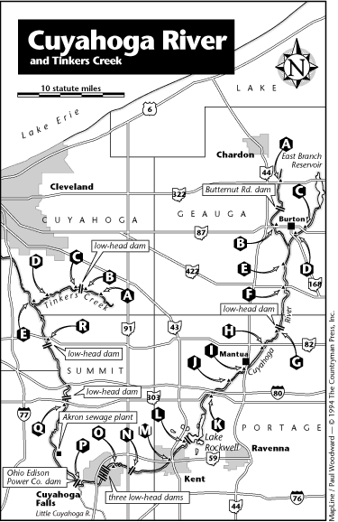
| Roadside pulloff at S.R. 87 bridge east of Burton, access river right |
|
X |
|
|
|
|
|
|
|
|
Geauga |
| Russell Park (Geauga Co. Park) off Rapids Road northeast of LaDue Reservoir south of Burton, access river right |
|
X |
|
X |
|
X |
|
X |
X |
|
Geauga |
| DAM - broken at Camp Hi Canoe Livery off Abbott Road south of Hiram Rapids, portage river left if necessary |
|
|
|
|
|
|
|
|
|
|
Portage |
| Camp Hi Canoe Livery off Abbott Road south of Hiram Rapids, access river left with permission |
|
X |
X |
X |
|
X |
|
|
X |
X |
Portage |
| Save 4 Store off S.R. 303 bridge southwest of Streetsboro, access river left (access to bridge is privately owned); for permission call Chuck Eisle at (216)626-3967 |
|
X |
|
|
|
|
|
|
X |
X |
Portage |
| River is restricted from the S.R. 303 bridge southwest of Streetsboro to below the spillway at Lake Rockwell north of Kent, last takeout is the Save 4 Store in Streetsboro |
|
|
|
|
|
|
|
|
|
|
Portage |
| Lake Rockwell spillway, access river right |
|
|
|
|
|
|
|
|
|
|
Portage |
| Access behind Standing Rock Cemetery off S.R. 43 and Standing Rock Avenue at northern edge of Kent, access river right |
|
X |
|
X |
X |
|
|
|
|
|
Portage |
| DAM - below Main Street bridge in Kent, portage river right at pathway |
|
|
|
|
|
|
|
|
|
|
Portage |
| Fuller Park off Middlebury Road in Kent, access river right or left |
|
X |
|
|
X |
X |
|
X |
X |
|
Portage |
| DAM - above the S.R. 91 bridge (Main Street) in Monroe Falls, portage river right |
|
|
|
|
|
|
|
|
|
|
Summit |
| Park off S.R. 91 (Main Street) in Monroe Falls, access river right or left |
|
X |
|
|
|
|
|
|
|
|
Summit |
| Takeout access at Riverfront Park off Front Street in Cuyahoga Falls - MANDATORY TAKEOUT BEFORE DAMS, access river right |
|
X |
|
|
|
|
|
|
|
|
Summit |
| DAM - upstream of Broad Boulevard in Cuyahoga Falls, NO PORTAGE; Takeout at No. 12 |
|
|
|
|
|
|
|
|
|
|
Summit |
| DAM - downstream of Broad Boulevard in Cuyahoga Falls, NO PORTAGE; Takeout at No. 12 |
|
|
|
|
|
|
|
|
|
|
Summit |
| FALLS - begins at last dam downstream of Broad Boulevard in Cuyahoga Falls; averages a class 4-5 rapids; they are runnable with considerable risk to equipment and life, RESTRICTED AREA, takeout access river right |
|
|
|
|
|
|
|
|
|
|
Summit |
| DAM - Gorge Metropolitan Park dam in Cuyahoga Falls; below dam are more class 3-4 rapids; they are runnable with considerable risk to equipment and life, RESTRICTED AREA, takeout access river right |
|
X |
|
|
|
|
|
|
|
|
Summit |
| Athletic field off Cuyahoga Street at northern limits of Akron, access river right |
X |
|
|
|
|
|
|
|
|
|
Summit |
| North Portage Path Road bridge at northern edge of Akron, access river left under bridge |
X |
X |
|
|
|
|
|
|
|
|
Summit |
| Bolanz Road bridge south of Everett, access river right |
X |
|
|
|
|
|
|
|
|
|
Summit |
| Ira Road bridge at Ira, access river left |
X |
|
|
|
|
|
|
|
|
|
Summit |
| DAM - downstream of the S.R. 303 bridge in Peninsula, portage river right |
|
|
|
|
|
|
|
|
|
|
Summit |
| Access below Peninsula dam below S.R. 303 bridge in Peninsula, access river right |
|
X |
|
|
|
|
|
|
|
|
Summit |
| CUYAHOGA VALLEY NATIONAL RECREATIONAL AREA IS CURRENTLY PUTTING A CANOE ACCESS PLAN IN OPERATION. CHECK WITH CVA FOR INFORMATION |
|
|
|
|
|
|
|
|
|
|
Summit |
| Highland Road bridge east of Jaite, pulloff access river right |
|
X |
|
|
|
|
|
|
|
|
Cuyahoga |
| Closed Station Road bridge below the S.R. 82 bridge east of Brecksville, pulloff access river right or left |
|
X |
|
|
|
|
|
|
|
|
Cuyahoga |
| DAM - below the S.R. 82 bridge east of Brecksville, portage river right |
|
|
|
|
|
|
|
|
|
|
Cuyahoga |
| Heritage Park in Cleveland on Merwin Avenue close to the mouth of the Cuyahoga River, access river right |
|
X |
|
|
|
|
|
|
|
|
Cuyahoga |